Test Locations To See If Mapshare Is Working For You

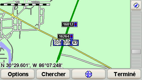
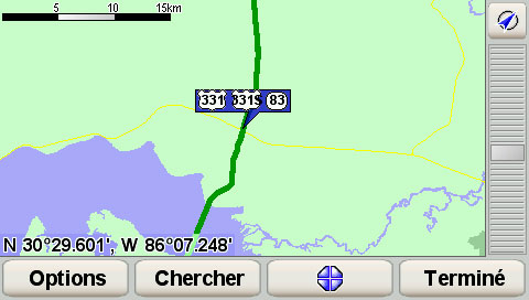
I found a great one. According to TomTom, this is a road. Google shows it as a road, too, since they use TeleAtlas data.

But if anyone attempts to follow it, they're going to be on the news... because it's not a road. It's a drainage ditch.

I specifically mentioned the problem in the text notes of the "Street does not exist" MapShare report, so we'll see what they do. I previously submitted the error (without comment) from my v.7 map, but that was in January when the map was already obsolete. I haven't entered it on the TeleAtlas site -- should I, or would that spoil the surprise? :)
 
As always,users should use a GPS as a "tool" and not as your eyes,heck I wouldn't listen to someone in the passenger seat telling me to "turn here",why a piece of metal/plastic.

I dunno... but I had to turn off the "GlaDOS" voice I installed, that lies to you. I found myself wanting to follow her directions, even though I *knew* that all the rights said "left" and all the lefts said "right".
 
Westbound SR-528 (Beachline Expressway) is indicated as a toll road, from Cape Canaveral on. This is true, only if you continue west past I-95. So long as you exit before, or on I-95, there are no tolls. If you are in Cape Canaveral, and you have preferences set to avoid tolls, and you want to go to Cocoa or Titusville, you will have a long round about journey.

Coordinates listed are for last exit without a toll.

N 28.41279 W 80.81515
 
Can someone take a look on the new 8.25 map and see if the by-pass for Freeport,FL has been corrected.

lat (30.493355 )
lon (-86.120796 )

This by-pass was completed about 16 months ago. I had reported in the past 3 map versons and 3 times to tele atlas but on ver 8.15 it still wasn't corected.

If you look at this location on Google maps it dosn't show as corrected but if while you are in Google maps an click on satellite view and then drag the little man to the intersection of Hwy 331 N//B & Hwy 20 E/W you can see the construction beign completed and the section of Hwy 331 going north of Hwy 20
 
The Google TA map is more recent than TT's 8.25, so my guess is that's it's not corrected yet and won't be in the next release either.
 
Can someone take a look on the new 8.25 map and see if the by-pass for Freeport,FL has been corrected.

lat (30.493355 )
lon (-86.120796 )

This by-pass was completed about 16 months ago. I had reported in the past 3 map versons and 3 times to tele atlas but on ver 8.15 it still wasn't corected.

If you look at this location on Google maps it dosn't show as corrected but if while you are in Google maps an click on satellite view and then drag the little man to the intersection of Hwy 331 N//B & Hwy 20 E/W you can see the construction beign completed and the section of Hwy 331 going north of Hwy 20

I've just cross check and I can't see an extending northbound 331 on google maps, but I can see one alright on the Go930 with 8.25 maps, passing west of 1st american farms!

I can't take a screenshot for now (operate my go not working with latest FW), but if you prefer waiting (I don't know this area), I will try posting one later.
 
You know you can take a screen shot with your TomTom (without using OMG) Really pretty simple.

1) Connect your TomTom to your computer and create a folder in the TT root drive called simply "screen".

2) Then make a text file, with nothing in the file, and save it with the name 'capture', no file extension at all.

3) Put the file in the 'screen' folder you created.

4) Disconnect your TomTom and let it reboot. When you want to do a screen shot, click near the top left of the screen near where the zoom button should be. It's a little tricky at first to find the right spot to press, but if you do it correctly you'll hear a "camera shutter" sound. The screenshot you just took is now in the "Screen" folder you made, saved as a bitmap. The feature will stay active as long as your TT sees the Screen folder. I just go back in and change it to Screen1 when I don't want it active. Which is most of the time.

I'm sure this tip is in here somewhere, but just thought I'd point it out to new members who have never heard of this "unoffficial" feature.

That's cool a feature! thanks for the tip!!!

Here are the screenshots. Close up and larger range!

dump2039831485.jpg


dump2039831486.jpg
 
I've just cross check and I can't see an extending northbound 331 on google maps, but I can see one alright on the Go930 with 8.25 maps, passing west of 1st american farms!

I can't take a screenshot for now (operate my go not working with latest FW), but if you prefer waiting (I don't know this area), I will try posting one later.


Just for the heck of it now go to google maps and plan a rout from south of freeport to say Hwy 10 and see what you get. You will now have Google take you through the middle of the field with No hwy north of Hwy untell you conect back onto 331 NB about 3-5 miles north of Freeport.

Sooooooo in the new 8.25 map it is more up to date than the TA google map at this time or at least in this example.


freeport.jpg


Google T/A Map 2009

dump1677055274.jpg

8.25 map
 
Last edited:
Just for the heck of it now go to google maps and plan a rout from south of freeport to say Hwy 10 and see what you get. You will now have Google take you through the middle of the field with No hwy north of Hwy untell you conect back onto 331 NB about 3-5 miles north of Freeport.

Sooooooo in the new *.25 map it is more up to date than the TA google map at this time or at least in this example.

Map 825 is based on the October 08 teleatlas map, plus some tomtom-specific corrections. Google is based AFAIK, 100% on the teleatlas map, and is curently 1 version newer than tomtom, using the Feb 09 teleatlas map.

I thought that 825 was a pure copy of the October map (99% of my errors exist in both versions), but I found a case where a physical road chance is in 825 that isn't in teleatlas/google, This makes the 2 cases that I found. So tomtom is still doing post-teleatlas updates/corrections to their maps.

This is a good thing, because teleatlas made a pretty big mistake in my area in the Feb 09 update, and hopefully it isn't more widespread. There were two instances where the wrong road was erased about 250ft west of a road that should have been erased. These areas haven't changed in 5 years, and there no ambiguity about where the erasures should be if someone physically drove and verified things. I suspect teleatlas was attempting to integrate the "validated by tomtom" mapshare edits into their base map by an automated electronic overlay, but go the coordinates off by 250 feet. Hopefully tomtom's post-teleatlas review finds and corrects this before releasing the May map update.
 
I submitted this error correction several months ago, and just purchased the new map, the error is still there.

GPS coordinates:
N 43.031832
W 89.468455
Map shows Lewon Dr going through median strip on Raymond Rd
Lewon Dr does not go through median strip, there is just grass there
Street type: Minor
Change: Permanent
Map USA 2 GB v 825.2157

Google has it wrong, MapQuest has it correct.
 
Unfortunately, if a correction is submitted by relatively few people, the priority for its inclusion in the next map, or the next, is often pretty low down the totem pole.
 
Here's another error correction from several months ago. The new map, the error is still there.

GPS coordinates:
N 43.060204
W 89.552212
Missing street
Bear Claw Way goes from the intersection of Mineral Point Rd north to Brader Way (Brader Way is also missing). These streets have been there a year now, but are still missing from the map.
Street type: Minor
Change: Permanent
Map USA 2 GB v 825.2157

Google has it wrong, MapQuest has it correct.
 
Street does not exist.

GPS coordinates:
N 43.060503
W 89.552919
Street does not exist
The map names this street "Blackhawk Way." That is incorrect. There is no street at this location. Other streets near here that do exist are not on the map.
Street type: Minor
Change: Permanent
Map USA 2 GB v 830.2284

Google has it wrong, MapQuest has it correct.
 
Last edited:
Unfortunately, if a correction is submitted by relatively few people, the priority for its inclusion in the next map, or the next, is often pretty low down the totem pole.

Interesting that MapQuest has correct maps where the TomTom map is incorrect. MapQuest uses both TeleAtlas and Navteq. Maybe TomTom should as well.
 

Ask a Question

Want to reply to this thread or ask your own question?

You'll need to choose a username for the site, which only take a couple of moments. After that, you can post your question and our members will help you out.

Ask a Question

Staff online

Members online

Latest resources

Forum statistics

Threads
28,911
Messages
195,089
Members
67,861
Latest member
garoutte07

Latest Threads

Back
Top