XL avoids waypoints

Joined
Jun 12, 2016
Messages
5
Country
<img src="/styles/default/custom/flags/au.png" alt="Australia" /> Australia
TomTom Model(s)
XL
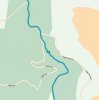
I have found that I cannot control the route my XL takes. I assumed that I adding a waypoint would fix this. The proposed route does not pass within 50 km of the waypoint. It does not matter whether I use "Travel Via" or "Itinerary Planning", the result is the same. The Tom Tom goes out of its way to use the nearest freeway.

Comparing the XL with Google Maps for this route, the XL selects a route of 216km (3h17) as its first offering compared with Google which suggests a route of 177km (2h38). Google also takes the route I want as first preference.
When I add a waypoint to the XL route, about midway along the path it did not take, the distance changes to 233km and time to 3h28 (and it does not go anywhere near the waypoint)

Is there a setting I can tweak to get the XL to do what I want?
 
Your device should go to the waypoint if a route actually exists to it, but your device may very well still head for the highway immediately thereafter as it evidently believes it is a 'better' route based upon your current configuration and what it knows of the roads involved. So the fact that it seems unwilling to go to your waypoint is our second issue.

The larger issue is the routing that caused you to try to modify the route in the first place, and yes, it could be based upon settings. You have options for 'Shortest' (distance), 'Fastest' (time), and possibly even things like 'Avoid highways'. I don't recall all of the options that are specific to the XL. Check under 'Planning preferences' on your device.

If your XL thinks that its route is faster, regardless of distance, and you're configured for 'Always plan fastest routes', then it will sacrifice distance to gain time.

If you would check your current planning configuration and give us some stop / end points, we could look at it more thoroughly.
 
FWIW, this is more along the lines of a 'tech support' question (vs. discussion of a particular code release), so I'm moving the thread over there. I'll try to find a way to let you know by leaving a 'link' behind.
 
I drove the route yesterday. For this discussion, I have broken the trip into 3 legs, although the whole trip is only a few hours.
1. Starting in Tanjil South, Victoria, Australia to Noojee via Icy Creek using the C465, then
2. Noojee to Yarra Junction using the C425 and then
3. Yarra Junction to Alexandra

In leg 1, between the town of Willow Grove and the intersection of Duggan Road and the C465 near the town of Icy Creek (a distance of 18km as the crow flies), I was advised to "Turn around when possible". The ETA for Noojee increased as I drove on, but when I passed Duggan Road, the ETA dropped by 2 hours!

In leg 2, on the C425 at about 145 deg 47 min east longitude, I had a similar discontinuity where the ETA for Yarra Junction dropped by 1 hour.

Leg 3 was the worst. Not having a physical map to refer to, and assuming that two major map errors would be the most I was likely to find, I followed instructions to Alexandra. The XL took me by the C507 via Warburton instead of going through Healesville and up the B360. I am sure Warburton is a lovely place, but I did not need to go there. The C507 is winding and unsealed. Typical speed 30-40 km/h. No question from the XL about avoiding unsealed roads. Because I did not take the optimal route, I can't say where the next discontinuity is. I believe the route taken was about 30 minutes longer than optimal for this leg.

I can add that I have travelled legs 1 & 2 of this route about 5 years back and had no problems with the XL.

The current map of Australia is BROKEN in each leg. It seems to me that the reason the route I mentioned in my first post would not go near the way point was because of this. I have totally lost confidence in the current Tom Tom maps for Australia and I will not be recommending them to anyone now unless there is a simple fix.
 
My understanding is that the 970 map of Australia (along with that of certain other countries) has yet to be released so, indeed, a faulty map may be the problem. Call support for further info:

Australia
1300 135 604
Monday-Friday:9:00 am to 5:30 pm AEST
 
Thanks,
I will contact support next week.
FYI, the previous series of maps also had a discontinuity at approx 146 deg 19 min east, 37 deg 53 min south on Miller's Road, Upper Maffra West.
 
In leg 1, between the town of Willow Grove and the intersection of Duggan Road and the C465 near the town of Icy Creek (a distance of 18km as the crow flies), I was advised to "Turn around when possible". The ETA for Noojee increased as I drove on, but when I passed Duggan Road, the ETA dropped by 2 hours!
Turn around when possible? That should only happen if you've deviated (intentionally or otherwise) from the planned route.

It sounds to me as though there is a discontinuity in the mapping that caused the unit to believe it could not actually take the route that made more sense to you. You'd be surprised at what can happen. Know it sounds odd, but sometimes a bridge is reported as out or some other situation occurs that makes a particular route impossible, and is never changed once the problem with the road is resolved. More rarely, a road really will become discontinuous at some point in the map data, causing the device again to believe that the more sensible route just isn't possible.

Tomorrow I'll try to have a look at this using the TT mapping tool to see what happens when various versions of your first leg are proposed to see what happens here.
 
Well, some good news. Plotting the first leg of your route is now possible, so keep your fingers crossed for map 970. Route continues on past Duggan / Duggan North right on down C465 as you would expect.

Still curious about that 'turn around when possible' business, though. Had you already started your journey before planning the route on the device, and at the time of planning completion, is it then that you were advised to turn around?
 

Attachments

  • Duggan.jpg
    Duggan.jpg
    142.5 KB · Views: 342
Plotting the first leg of your route is now possible said:
Thanks for that. I see that there is no timetable for map 970 for Australia.

Still curious about that 'turn around when possible' business said:
Since I could not program the route I was taking, I left the XL running. Naturally it wanted me to go back following the only route it had.
 
The new map release fixes all of the faults I found above.
I hope that applies to the ones I did not find!
 

Ask a Question

Want to reply to this thread or ask your own question?

You'll need to choose a username for the site, which only take a couple of moments. After that, you can post your question and our members will help you out.

Ask a Question

Members online

No members online now.

Latest resources

Forum statistics

Threads
28,827
Messages
194,367
Members
67,762
Latest member
dave11a

Latest Threads

Back
Top