warning - long post..
FYI, this is about my 3rd go around with this question, and the 3rd similar answer. Thinking about the old saying that insanity can be described as doing the same thing over and over again and expecting a different result. Anyway, here is the deal:
After over two years of hearing that up to date Alberta coverage was "imminent", there still is no change, so again I write TomTom support and ask about it. This time I just want a simple answer to a simple question: WHEN does TomTom estimate Alberta coverage will be brought current? I would have been happy with a ball park estimate, or even them telling me they have no idea when, but it seems they can't do anything other than give standard canned answers. 6 weeks ago I send in this letter:
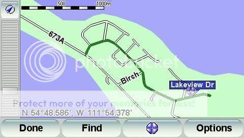
When are you going to get up to date maps for Alberta, currently TeleAtlas coverage is still missing and/or is inaccurate most of the rural areas outside the major cities, and there is no point in spending money on new maps that still do not show roads that have been in place for 3 decades. An example of Teleatlas coverage compared to Navteq coverage for the area I live in is attached, the data for it was just taken today.
I attached a jpeg comparing teleatlas and navteq maps for my area to this letter. Some weeks later I get this answer:
Thank you for contacting TomTom Customer Support regarding Alberta and your current map.
It is estimated that 10-15% of the road network changes every year. There is also inevitably some human error/subjectivity in the creation of a digital map. All of which means that maps must be constantly maintained to keep the level of map errors as low as possible. Tele Atlas has extensive survey teams constantly surveying new roads, changed roads, POI positioning and accuracy, map errors, etc. Each change and fix is then checked before being built into the next map release. TomTom predominantly uses Tele Atlas maps, then compiles the map vendor release (i.e. compresses it into a TomTom proprietary and specific format) and has it error-checked by TomTom?s own Quality Assurance team. This complex and labor-intensive process can mean it is several months before a map vendor?s new release is ready and fit for use in a TomTom product.
TomTom publishes four new map releases for customers per year, and by only using the latest available map releases from map vendors, TomTom ensures its customers always have the most recent map release in their newly purchased product. And all TomTom products are updatable. That is, the maps can be replaced with later map releases or added to with additional map regions.
Due to the high frequency of new map releases, there is a small chance that a new map is released between the production of a TomTom and the date that it is sold in retail. TomTom's recent products therefore come with a Latest Map Guarantee to allow users to check whether there is a more recent map release available. If a more recent map is available within 30 days of using the device, the user can download it at no charge via TomTom HOME.
TomTom has also introduced the unique and patented TomTom Map Share? technology. Map Share? revolutionizes electronic mapping by allowing users to instantly make corrections to the maps on their devices. These corrections take effect immediately. Corrections can also be shared with the entire TomTom community through TomTom HOME, making it possible to benefit from the local road knowledge of millions of other drivers.
I am sending you the link to the website which will provide you information on the MapShare program. Please click on the link below to view the information. If you are unable to click on the link, please copy and paste it into your internet browser.
TomTom, portable GPS car navigation systems - Support home - Select your product
If you have any further questions or comments, please email or call us at 866-486-6866 Monday through Friday, 7:00 AM until 11:00 PM EST.
With Best Regards,
<customer service rep>
Tom Tom Customer Support
So, other than the 1st sentence, a standard canned answer. My reply:
Thank you for your reply, unfortunately it does not even come close to answering my questions. I asked when are maps for Alberta, Canada, going to be brought up to date. I am not talking about errors per se, but the fact that road systems that are over two decades old are still not showing up on any teleatlas maps.
I bought my TomTom over two years ago now, and have heard time and time again that accurate Alberta maps were imminent, yet they are still hopelessly our of date. I am certainly not ready to spend a large amount of money on a new map that I know will not be accurate for rural Alberta, and hope that an accurate one will be out within the 30 day window like you suggest.
My question is simple, and a simple answer is all I want:
When do you estimate that the maps for Alberta will to be brought up to date? Next month?, next year? in two years?
If this level of support does not have an answer for this question, please forward it to someone that can give me an estimate, even a "ball park" would do at this point.
I have also put in mapshare corrections by the dozens, from wrong roads, gps off road, you name it. I have yet to see these shares show up in my updates, which I do often.
I have pointed out many errors on teleatlas site, many times, and the result is the same, no feedback, no corrections.
I am very disappointed in this product, and working in a GIS related field I get many questions on what are good units to buy. Unfortunately I can't recommend people buy TomTom units as they are still virtually unusable in Alberta.
Another few weeks pass, and I get this in my inbox this morning:
Dear Sir or Madam,
Thank you for allowing us to be of service to you. We have not heard back from you and the incident is now closed. We?d be happy to continue to service you if you still require assistance. Simply update this incident if you feel your original query has not been resolved or create a new incident if you have a new question.
We can always be reached through our Customer Support line via 1-866-486-6866.
Thank you and Best Regards,
The TomTom Customer Support Team
So there you have it, "we can't answer you, so we consider this solved"
I am tempted to answer again, but it's kind of like banging my head against a wall.
Oh well, guess it's time to ebay my 720 and go for a unit that uses Navteq..
FYI, this is about my 3rd go around with this question, and the 3rd similar answer. Thinking about the old saying that insanity can be described as doing the same thing over and over again and expecting a different result. Anyway, here is the deal:
After over two years of hearing that up to date Alberta coverage was "imminent", there still is no change, so again I write TomTom support and ask about it. This time I just want a simple answer to a simple question: WHEN does TomTom estimate Alberta coverage will be brought current? I would have been happy with a ball park estimate, or even them telling me they have no idea when, but it seems they can't do anything other than give standard canned answers. 6 weeks ago I send in this letter:
When are you going to get up to date maps for Alberta, currently TeleAtlas coverage is still missing and/or is inaccurate most of the rural areas outside the major cities, and there is no point in spending money on new maps that still do not show roads that have been in place for 3 decades. An example of Teleatlas coverage compared to Navteq coverage for the area I live in is attached, the data for it was just taken today.
I attached a jpeg comparing teleatlas and navteq maps for my area to this letter. Some weeks later I get this answer:
Thank you for contacting TomTom Customer Support regarding Alberta and your current map.
It is estimated that 10-15% of the road network changes every year. There is also inevitably some human error/subjectivity in the creation of a digital map. All of which means that maps must be constantly maintained to keep the level of map errors as low as possible. Tele Atlas has extensive survey teams constantly surveying new roads, changed roads, POI positioning and accuracy, map errors, etc. Each change and fix is then checked before being built into the next map release. TomTom predominantly uses Tele Atlas maps, then compiles the map vendor release (i.e. compresses it into a TomTom proprietary and specific format) and has it error-checked by TomTom?s own Quality Assurance team. This complex and labor-intensive process can mean it is several months before a map vendor?s new release is ready and fit for use in a TomTom product.
TomTom publishes four new map releases for customers per year, and by only using the latest available map releases from map vendors, TomTom ensures its customers always have the most recent map release in their newly purchased product. And all TomTom products are updatable. That is, the maps can be replaced with later map releases or added to with additional map regions.
Due to the high frequency of new map releases, there is a small chance that a new map is released between the production of a TomTom and the date that it is sold in retail. TomTom's recent products therefore come with a Latest Map Guarantee to allow users to check whether there is a more recent map release available. If a more recent map is available within 30 days of using the device, the user can download it at no charge via TomTom HOME.
TomTom has also introduced the unique and patented TomTom Map Share? technology. Map Share? revolutionizes electronic mapping by allowing users to instantly make corrections to the maps on their devices. These corrections take effect immediately. Corrections can also be shared with the entire TomTom community through TomTom HOME, making it possible to benefit from the local road knowledge of millions of other drivers.
I am sending you the link to the website which will provide you information on the MapShare program. Please click on the link below to view the information. If you are unable to click on the link, please copy and paste it into your internet browser.
TomTom, portable GPS car navigation systems - Support home - Select your product
If you have any further questions or comments, please email or call us at 866-486-6866 Monday through Friday, 7:00 AM until 11:00 PM EST.
With Best Regards,
<customer service rep>
Tom Tom Customer Support
So, other than the 1st sentence, a standard canned answer. My reply:
Thank you for your reply, unfortunately it does not even come close to answering my questions. I asked when are maps for Alberta, Canada, going to be brought up to date. I am not talking about errors per se, but the fact that road systems that are over two decades old are still not showing up on any teleatlas maps.
I bought my TomTom over two years ago now, and have heard time and time again that accurate Alberta maps were imminent, yet they are still hopelessly our of date. I am certainly not ready to spend a large amount of money on a new map that I know will not be accurate for rural Alberta, and hope that an accurate one will be out within the 30 day window like you suggest.
My question is simple, and a simple answer is all I want:
When do you estimate that the maps for Alberta will to be brought up to date? Next month?, next year? in two years?
If this level of support does not have an answer for this question, please forward it to someone that can give me an estimate, even a "ball park" would do at this point.
I have also put in mapshare corrections by the dozens, from wrong roads, gps off road, you name it. I have yet to see these shares show up in my updates, which I do often.
I have pointed out many errors on teleatlas site, many times, and the result is the same, no feedback, no corrections.
I am very disappointed in this product, and working in a GIS related field I get many questions on what are good units to buy. Unfortunately I can't recommend people buy TomTom units as they are still virtually unusable in Alberta.
Another few weeks pass, and I get this in my inbox this morning:
Dear Sir or Madam,
Thank you for allowing us to be of service to you. We have not heard back from you and the incident is now closed. We?d be happy to continue to service you if you still require assistance. Simply update this incident if you feel your original query has not been resolved or create a new incident if you have a new question.
We can always be reached through our Customer Support line via 1-866-486-6866.
Thank you and Best Regards,
The TomTom Customer Support Team
So there you have it, "we can't answer you, so we consider this solved"
I am tempted to answer again, but it's kind of like banging my head against a wall.
Oh well, guess it's time to ebay my 720 and go for a unit that uses Navteq..