Hi Everyone...
Ok...here is my dilemna....Fortunately I have a 910 and it has tons of storage. With that being said I have the older maps (Version North America v650.1108) and the newest maps (Version North America v665.1293).
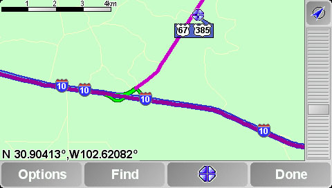
When I plan a route on Interstate 10 eastbound from Fort Stockton Texas...to San Antonio Texas with the v665 maps...no matter what I do there is a dogleg that goes up to Hwy 67/385 near McCawley Tx. Via fastest and shortest routes. I have also tried putting numerous waypoints along I-10 to see if it will go past this detour to no avail.
The only way to get the route to work is to go back to the old Version 650 maps.
Would it be possible to see if one of you could calc a route on I-10 eastbound to San Antonio From Fort Stockton Texas using the v665 maps and let me know what you get?
I think there is a problem either with the map or the tom tom logic but I think it is just the maps because when I revert back to the old V650 maps the same route calculates just fine.
Also...what (if anything) can we do about this problem?
Thanks in advance!!!!
Ok...here is my dilemna....Fortunately I have a 910 and it has tons of storage. With that being said I have the older maps (Version North America v650.1108) and the newest maps (Version North America v665.1293).
When I plan a route on Interstate 10 eastbound from Fort Stockton Texas...to San Antonio Texas with the v665 maps...no matter what I do there is a dogleg that goes up to Hwy 67/385 near McCawley Tx. Via fastest and shortest routes. I have also tried putting numerous waypoints along I-10 to see if it will go past this detour to no avail.
The only way to get the route to work is to go back to the old Version 650 maps.
Would it be possible to see if one of you could calc a route on I-10 eastbound to San Antonio From Fort Stockton Texas using the v665 maps and let me know what you get?
I think there is a problem either with the map or the tom tom logic but I think it is just the maps because when I revert back to the old V650 maps the same route calculates just fine.
Also...what (if anything) can we do about this problem?
Thanks in advance!!!!