Route on MyDrive different to that synced with 550

Great. That's enough information to write up a pretty 'clean' issue for TT to chew on.
 
Orange line is route in ridewithgps
Blue line is it in MyDrive
Blue route (black background) is my tomtom with synced route from MyDrive
As a side note - won't be investigating this one - I wonder if TomTom thinks that weird acute turn is not a legal turn and therefore insists upon just using the roundabout as intended.
acute.jpg
 
OK. Report submitted to some folks who might be able to explain this. Will be curious to see what, if anything, comes of it. Note that there IS a possibility that MyDrive modified the data prior to sending it to your 550, or it could be your 550 that is routing the data it received with less than 100% fidelity. We really don't know yet.

--------------------------------------------------------


I had always been under the impression that when uploading a trkpt *.gpx file to MyDrive (web), that the device receiving this data would attempt to follow that track as precisely as the road geometry allows, no matter what … even if the route would otherwise be considered suboptimal (closed roads, traffic, etc.). It seems that is not the case, and we are searching for an explanation for the behavior outlined below and any possible solution for it. This is but one example among many that were discovered and brought to our attention by a Rider 550 user. I have chosen this one for its simplicity and clarity in describing the issue.

The user created a track point (trkpt) style *.gpx file and uploaded to MyDrive (web). After syncing that file to his Rider 550, he found that the track he believed he had sent was not being followed with the expected fidelity by his Rider 550.

It will be demonstrated below that the uploaded track does indeed follow geometry known by both MyDrive (web) and the device, but the route subsequently created by the Rider 550 routing does not follow that geometry.


Q: Was the data modified by MyDrive (web) to avoid the diversion prior to sending it to the 550, or is the 550 choosing, for whatever reason, to ignore the lay-by area when creating its route from the *.gpx track data? Where is the bug, and can anything be done to avoid this problem? That’s what we would like to understand.


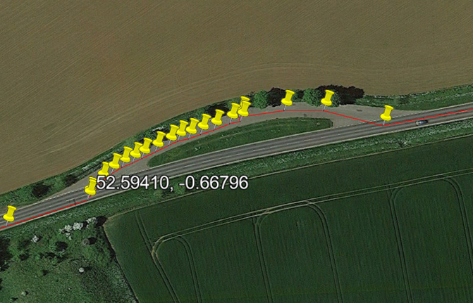
Here we first plot the *.gpx track points using Google Earth, and confirm that the lay-by diversion actually exists within the list of track points. As noted in this GE view for anyone who would do the analysis of this problem, the lay-by occurs eastbound (it’s the UK, so yes, they’re approaching on the ‘other’ side of the road) at 52.59410, -0.66796.

abd80613-50da-478d-ae18-174e8722d01b.png

1685380171281.gif


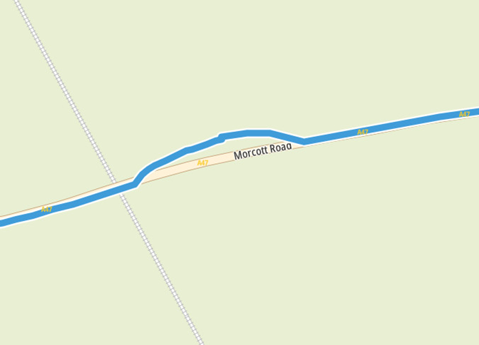
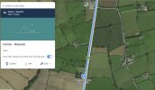
Here we inspect the uploaded *.gpx file of track points on MyDrive (web). It is clear that MyDrive has received and understands the desired track through the lay-by diversion.

5ecd2cd6-9233-417a-9d4f-85ca131596df.png

1685380171312.gif


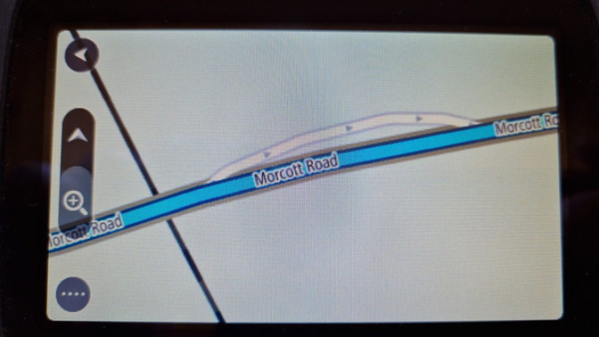
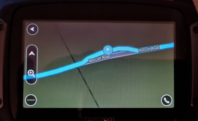
Note, however, that after receiving the track file from MyDrive (web) sync, the 550 has bypassed the diversion into the lay-by area.

06159fc3-0660-456b-9db0-1f78cfc1a37c.png

1685380171346.gif


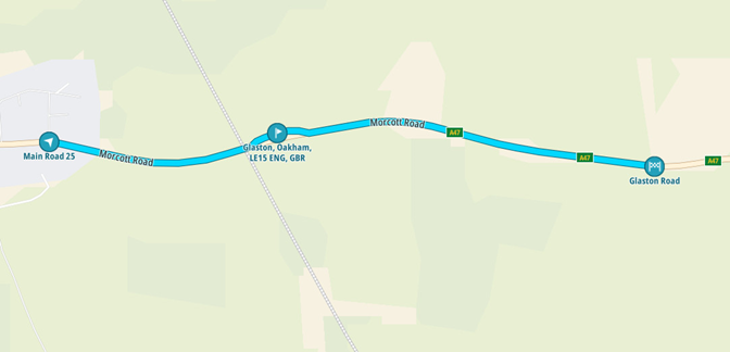
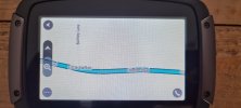
Below, a route is planned on MyDrive (web) with start and stop points either side of the lay-by, and a ‘stop’ within the lay-by area is added to the route. As can be seen, the 550 device has no issues with using this little piece of geometry for routing when asked to do so.

7a042515-bc31-43e5-b5ea-f63b4f68ee35.png

1685380171377.gif


Below, a route is planned on the 550 itself with start and stop points either side of the lay-by, and a ‘stop’ is added to the route. As can be seen, the 550 also has no issues with using this little piece of geometry for routing when asked to do so.

b2c4033d-59f9-417f-8770-47cae7b2896a.png

1685380171409.gif


In Settings > Route Planning, the 550 is configured as follows:

When there is no route planned
'Suggest destinations' is set to 'On'

When a faster route is available
'Ask me so I can choose' is selected

Always plan this type of route
'Fastest route' is selected

Avoid on every route
Nothing is selected to 'On'
 
Last edited:
Brilliant, thank you for taking this up for me.

It's good to know it's not me doing something wrong.

Fingers crossed they come up with a solution...meantime, I shall try to come up with a workaround for the trip to Ireland.

Regards.
 
Brilliant, thank you for taking this up for me.

It's good to know it's not me doing something wrong.
Well maybe it is and maybe it isn't. Were you standing on your right or left foot or both when you hit the enter key to upload the *.gpx file to TomTom?
 
@canderson

If I understand it correctly the rider is approaching the layby from the east (RHS of the picture) and wishes to turn into the layby which is on the opposite side of the road.
However this image seems to shown the layby is one way
1685633861388.png

This would mean that the track as plotted cannot be achieved.
However examination of Google streetview does not show any one-way, no-entry or restricted entry signs.
Could the answer merely be that the layby is incorrectly classified on the mapping in the 550?
 
@TonyGr

OP is in the UK. I'll double check, but I believe the route is eastbound at that point. The track doesn't perfectly overlay the TT map geometry, giving the mistaken impression that the track was westbound at this point. The lay-by is indeed considered 1 way in the TT geometry as is evidenced in the 550 display.
 
My mistake. I saw the position of the red line on the Google map view and, knowing we drive on the left in the UK assumed he was heading west
I also noted that the Google map shows the layby as one way and, indeed, there is another layby not far away on the opposite side so why would any driver/rider choose to cross over.
 
To confirm, route is eastbound (in UK), lay by is an opportunity on the route to pull into and pause.

The idea being that I don't miss the lay by if I was to route straight past it.

I have routes to do later in the year where I'm leading 18bikes and those planned routes do the same thing for my 'pauses'.

This layby was part of a route to test for myself if the lay by would be on the route and try to see if I was doing something wrong.
As explained above, the layby pause is on mydrive web but the sync to the 550 removes it.
 
Further evidence of route not transferring to the 550.

First picture is a point created in TomTom Route Planner @ 52.754122, -1.059886
Second picture is 550 ignoring it

3rd picture is a another pull in created in TomTom Route Planner @ 53.105707, -0.836536
4th picture is 550 ignoring it.

This is so frustrating and if planning a long route, it is pointless having to check the whole route on the 550 to see if it's missed anything or not....
 

Attachments

  • Screenshot 2023-06-17 123124.jpg
    Screenshot 2023-06-17 123124.jpg
    563.6 KB · Views: 9
  • HN - 1 550.jpg
    HN - 1 550.jpg
    796 KB · Views: 7
  • Screenshot 2023-06-17 123034.jpg
    Screenshot 2023-06-17 123034.jpg
    600 KB · Views: 6
  • HN - 2 550.jpg
    HN - 2 550.jpg
    833.5 KB · Views: 7
Still haven't had any reply from anyone at TomTom on this.
 

Ask a Question

Want to reply to this thread or ask your own question?

You'll need to choose a username for the site, which only take a couple of moments. After that, you can post your question and our members will help you out.

Ask a Question

Members online

No members online now.

Latest resources

Forum statistics

Threads
28,885
Messages
194,927
Members
67,839
Latest member
Mandylf68

Latest Threads

Back
Top