
You are using an out of date browser. It may not display this or other websites correctly.
You should upgrade or use an alternative browser.
You should upgrade or use an alternative browser.
Route on MyDrive different to that synced with 550
- Thread starter bobbley
- Start date

canderson
Moderator
- Joined
- Dec 28, 2007
- Messages
- 13,219
- Location
- Colorado, USA
- TomTom Model(s)
- GO720, GO740, GO 1535, Via 1535, Via 1605, GO 52, GO 600, GO 620, GO 630, GO Discover, TomTom Bridge
If I understand correctly, you have created a route that you believe causes a diversion onto a side road from Morcott Road, but the Rider 550 bypassed your diversion?
Much depends upon what flavor of *.gpx you imported to MyDrive. If it was a wpt style *.gpx, and there were points within that diversion, then the 550 should not have bypassed it. If it was a rtept style *.gpx, there would have needed to have been a point within the diversion as well. Can you provide a zip file of your *.gpx?
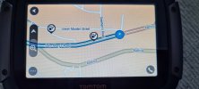
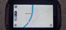
There seems an odd discontinuity in diversion in the route in the top photo. Is that hand drawn, or was that the result drawn by MyDrive? It looks as though the *.gpx didn't perfectly follow the road geometry.
Much depends upon what flavor of *.gpx you imported to MyDrive. If it was a wpt style *.gpx, and there were points within that diversion, then the 550 should not have bypassed it. If it was a rtept style *.gpx, there would have needed to have been a point within the diversion as well. Can you provide a zip file of your *.gpx?
There seems an odd discontinuity in diversion in the route in the top photo. Is that hand drawn, or was that the result drawn by MyDrive? It looks as though the *.gpx didn't perfectly follow the road geometry.
Last edited:
Thanks for the reply.
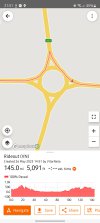
I created the route on ridewithgps allowing for a pull in, into a lay by.
I exported the gpx file into MyDrive and the route is correctly displayed on MyDrive as per the top image.
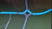
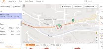
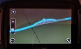
Syncing with my tomtom ie just switching in MyDrive to sync with my devices results in the route in my tomtom becoming that in the bottom picture (which is a screen shot of my tomtom)
Ie the tomtom appears to 'smooth' the route.
This isn't the only time it happens: little spurs here and there into petrol stations or a car park are all shown in MyDrive, but the sync results in these little 'off route' things being lost.
I created the route on ridewithgps allowing for a pull in, into a lay by.
I exported the gpx file into MyDrive and the route is correctly displayed on MyDrive as per the top image.
Syncing with my tomtom ie just switching in MyDrive to sync with my devices results in the route in my tomtom becoming that in the bottom picture (which is a screen shot of my tomtom)
Ie the tomtom appears to 'smooth' the route.
This isn't the only time it happens: little spurs here and there into petrol stations or a car park are all shown in MyDrive, but the sync results in these little 'off route' things being lost.
canderson
Moderator
- Joined
- Dec 28, 2007
- Messages
- 13,219
- Location
- Colorado, USA
- TomTom Model(s)
- GO720, GO740, GO 1535, Via 1535, Via 1605, GO 52, GO 600, GO 620, GO 630, GO Discover, TomTom Bridge
Since I'm not interested in a monthly (or annual) subscription to ridewithgps, can you share the *.gpx as a *.zip file here, please? I'd like to see how the file was constructed. As noted, there are several flavors of *.gpx files, and it will be of interest to see what ridewithgps has created and how the 550 may be interpreting these.
For this ridewithgps route, I created it under my friends login (who does pay the subscription) to add some poi's and so I can see if they're picked up on my tomtom when I do the route.
The issue with 'smoothing' (as I'm calling it) has happened before and I've created this route with a couple of pull outs (if you will) from the main route just to help figure out what's going on.
I'm off to Ireland end of August, leading 18other bikes and all the routes are created in ridewithgps and I don't want my tomtom 'smoothing' out my planned pull ins, into laybys, garage forecourts and the like...
Orange line is route in ridewithgps
Blue line is it in MyDrive
Blue route (black background) is my tomtom with synced route from MyDrive
Blue line is it in MyDrive
Blue route (black background) is my tomtom with synced route from MyDrive
Attachments
canderson
Moderator
- Joined
- Dec 28, 2007
- Messages
- 13,219
- Location
- Colorado, USA
- TomTom Model(s)
- GO720, GO740, GO 1535, Via 1535, Via 1605, GO 52, GO 600, GO 620, GO 630, GO Discover, TomTom Bridge
OK. Have the file. Can you give me a rough idea of where in that route I should look for the anomaly that you are showing?
canderson
Moderator
- Joined
- Dec 28, 2007
- Messages
- 13,219
- Location
- Colorado, USA
- TomTom Model(s)
- GO720, GO740, GO 1535, Via 1535, Via 1605, GO 52, GO 600, GO 620, GO 630, GO Discover, TomTom Bridge
Alas -- I don't have any easy way to calculate location into the route by miles. Latitude/longitude are what I'd need to look at this more closely.
And yes, your app generated a 'trkpt' style *.gpx whose points should be specifically followed by the 550.
With the coordinates of the two issues you discovered, I can help to create a ticket at TomTom and see if other 550 era Rider users I know have seen similar issues and can duplicate.
And yes, your app generated a 'trkpt' style *.gpx whose points should be specifically followed by the 550.
With the coordinates of the two issues you discovered, I can help to create a ticket at TomTom and see if other 550 era Rider users I know have seen similar issues and can duplicate.
52.594101,-0.667959
52.599946,-0.535796
Coordinates as requested...copied from Google, so hope they're correct for you.
I'll try putting more points in...for example at the layby, one at the beginning, in it and at the exit.
Using that route today, the 550 wanted to take me off the route that I know I planned....whether it was joining the dots itself ie plotting fastest route between the 2 rather than follow the track?
I shall make sure my next route I create in Ridewithgps has plenty of control points.
Additionally, poi's created in ridewithgps didn't appear to transfer in the gpx file as they weren't displayed/shown at all on the 550, so that's something else I need to look at.
Thanks for your help.
B.
canderson
Moderator
- Joined
- Dec 28, 2007
- Messages
- 13,219
- Location
- Colorado, USA
- TomTom Model(s)
- GO720, GO740, GO 1535, Via 1535, Via 1605, GO 52, GO 600, GO 620, GO 630, GO Discover, TomTom Bridge
If the POIs were generated as waypoints <wpt> in the *.gpx file, TomTom doesn't deal with those at all and can't interpret them. I've lobbied to have <wpt> created as custom POI, but so far, no joy.
Thanks for the coordinates. I'll take a look at those points in more detail now.
Thanks for the coordinates. I'll take a look at those points in more detail now.
canderson
Moderator
- Joined
- Dec 28, 2007
- Messages
- 13,219
- Location
- Colorado, USA
- TomTom Model(s)
- GO720, GO740, GO 1535, Via 1535, Via 1605, GO 52, GO 600, GO 620, GO 630, GO Discover, TomTom Bridge
OK. I've looked at your first set of coordinates (52.594101,-0.667959) and the deviation is definitely showing up in your track points. That's a good enough example to get started. Thanks.
And because I just KNOW the question will come up, please supply the routing preferences / avoidances you had on your 550 when you found that it was not following the track seen below. Not that it fits this particular example, but it could be something as silly as declining to travel on unpaved roads and finding out that the lay-by was misclassified as unpaved. I've seen crazier things cause a route diversion.

And because I just KNOW the question will come up, please supply the routing preferences / avoidances you had on your 550 when you found that it was not following the track seen below. Not that it fits this particular example, but it could be something as silly as declining to travel on unpaved roads and finding out that the lay-by was misclassified as unpaved. I've seen crazier things cause a route diversion.
Last edited:
Thanks.
In Settings > Route Planning, it's set as the following:
When there is no route planned
'Suggest destinations' is set to 'On'
When a faster route is available
'Ask me so I can choose' is selected
Always plan this type of route
'Fastest route' is selected
Avoid on every route
Nothing is selected to 'On'
Hope that helps.
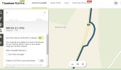
Another example on one of my Ireland route (as attached - rename to .gpx)
Petrol station at
52.448806, -9.053198
550 ignores the routing
Petrol station at
52.448806, -9.053198
550 ignores the routing
Attachments
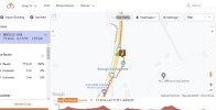
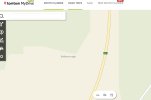
Another example in the same route above:
Layby at:
52.424623, -9.128387
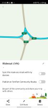
It might be worth noting that in MyDrive, the layby doesn't exist (last screen shot), yet it's still drawn the route (from the gpx file)...is that why on the 550 it's not drawing the route on the 550 - because it doesn't think it exists??
On the layby in the one you've already looked at - it is shown in MyDrive as something (different to the main road), but it may not be recognising it as a road to divert onto, so hence ignoring it on the 550??
Layby at:
52.424623, -9.128387
It might be worth noting that in MyDrive, the layby doesn't exist (last screen shot), yet it's still drawn the route (from the gpx file)...is that why on the 550 it's not drawing the route on the 550 - because it doesn't think it exists??
On the layby in the one you've already looked at - it is shown in MyDrive as something (different to the main road), but it may not be recognising it as a road to divert onto, so hence ignoring it on the 550??
Attachments
...reading all the above myself, it's looking like while Ridewithgps recognises any type of track/road/path/whatever that can be part of a route, MyDrive will happily recreate the route from the gpx route to view, but when it syncs with the TomTom, if the map doesn't recognise the 'off the main road' element, it ignores it and 'smoothes' it out...
canderson
Moderator
- Joined
- Dec 28, 2007
- Messages
- 13,219
- Location
- Colorado, USA
- TomTom Model(s)
- GO720, GO740, GO 1535, Via 1535, Via 1605, GO 52, GO 600, GO 620, GO 630, GO Discover, TomTom Bridge
Yes, that is how it appears, but it should not do that. If there are track points set in 'legitimate geometry', the 550 should route through that bit of map geometry and not around it. That they are legitimate, at least as far as MyDrive Web goes, is what we're about to demonstrate for this ticket in this post....reading all the above myself, it's looking like while Ridewithgps recognises any type of track/road/path/whatever that can be part of a route, MyDrive will happily recreate the route from the gpx route to view, but when it syncs with the TomTom, if the map doesn't recognise the 'off the main road' element, it ignores it and 'smoothes' it out...
Understand, however, that what MyDrive web shows are the results of the raw trackpoints that were uploaded in the *.gpx, which it, and the device, may or may not consider a viable routing for one reason or another. However, as the MyDrive screen shot below demonstrates, that's not the case for MyDrive web. It allows a waypoint to be added in the lay-by on this short little eastbound route. That's what makes this case an easy one to use to demonstrate the issue, so I'll just work with this one.
Next, we'll want to know what happens if, on your 550, you plan a short route from 52.59422, -0.67579 to 52.59370, -0.65220 and then add a stop at 52.59444, -0.66691 at the lay-by. Doing it that way, what does the 550 show? If you're not sure how to enter locations on your 550 with coordinates, it's done by clicking the "Whole map" button in the upper right of "Search" and scrolling down to the bottom where it allows for entry of lat/long data.
Send along a pic of what the 550 does with that. I want to exclude road type issues in the 'Classic' style map on your 550 from the discussion that is bound to follow with TomTom. I'm trying to avoid a lot of unnecessary questions back and forth so that we can get to the actual issue more quickly.
Last edited:
Ask a Question
Want to reply to this thread or ask your own question?
You'll need to choose a username for the site, which only take a couple of moments. After that, you can post your question and our members will help you out.
Similar Threads
Forum statistics
Latest Threads
-
Need to format 6250 internal memory
- Started by Jim ridley
-
Tom Tom Go 5200 - POLICE RADARS
- Started by JMS
-
Speed Camera Updates / Premium Services
- Started by Leebroath
-
Rider 550 Track names no longer being imported
- Started by Barbieboy
-
IOS APP Doesn't work
- Started by Csontimontir
-
Navigate to "Nearest point" is not the nearest point.
- Started by Stijn_vdh
-
Vlaamse stemmen
- Started by Tennisplayer
-
Help
- Started by icemanhgv
-
Scenic Segments in Map Options
- Started by SJW
-
Access an inaccessible site
- Started by Jac34