- Joined
- Sep 30, 2021
- Messages
- 9
- Country

- TomTom Model(s)
- Rider2
Hi
I'm having issues with my tomtom routes
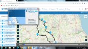
I develop the route in My Route App (MRA) the problem is when I download the route to my tomtom 410 it doesn't match what I created in MRA.
The first sign is the milage is different in the app to what it says on the tomtom and on close inspection the route in the tomtom does not follow the waypoints created in MRA even when I use loads of waypoints.
There's always been a slight descrepancy but now it is sometimes upto 10 miles out.
The settings for the route in the nav have never been changed but I've tryed them all anyway.
The nav is upto date
The nav is connected to mydrive when downloading route from MRA.
Has anyone had similar issues
I'm having issues with my tomtom routes
I develop the route in My Route App (MRA) the problem is when I download the route to my tomtom 410 it doesn't match what I created in MRA.
The first sign is the milage is different in the app to what it says on the tomtom and on close inspection the route in the tomtom does not follow the waypoints created in MRA even when I use loads of waypoints.
There's always been a slight descrepancy but now it is sometimes upto 10 miles out.
The settings for the route in the nav have never been changed but I've tryed them all anyway.
The nav is upto date
The nav is connected to mydrive when downloading route from MRA.
Has anyone had similar issues