Tripmaster V1.6 final version

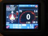
I do like your satellite icon, may I copy it into my current background ? or can you provide me one, in jpeg or psp format, in blue color ?

Here you go. WMF file for the satellite image.

Also, since Tripmaster has 2 modes (day and night), if one chooses a background that is black for example, you have to change the font color scheme for DAY. Otherwise, as it is set now, DAY uses black on white. So, essentially you don't get anything.

Roussillat - I'm also going to tweak the background I created. I'll post another version later. But in the future, feel free to download what I've uploaded and put it on your website.

And if I may request, in your future release (if you haven't thought of it yet):

1. Tweak the COMPASS option for NUM and LIT. I found out if I choose NUM, it'll show numeric in the middle of the compass AND show LIT(eral??) on the lower left hand corner. I would prefer to just show it on the lower left hand corner because it is very hard to read from the white text over white compass arrows. It'll even be better if you have an overlayed area in the middle of the compass for the info instead of just putting the text right on top of the compass arrow. That way you don't have white text/num over white arrow. Instead you have white text in a black background box over the white arrow. (see this - notice the 178/S is very hard to read over the arrows).

attachment.php


2. A way to choose different background image from your COLORS tab. So, that way we can load multiple images on the fly. In addition, have DAY background image as well. Personally, I prefer white on black. So I've no use for DAY.

3. A way to turn off the GPS coordinates from the menu. I can see this as being very useful when travelling to unknown places not contained in the map but for everyday use, it is a distraction.

4. A way to turn off logging HOTSPOT. Maybe coz' it's winter, I'm wearing gloves and bouncy car, but often time while driving, I find myself hitting the wrong spot on the screen and it activates the logging.

Thanks so much again for your effort in doing something TT should have come with.

EDIT:
I notice from your website, your compass rose is showing N/E/S/O. What's O?? Nevermind, it's coz' of your locale/language settings.
 

Attachments

  • satelite.zip
    934 bytes · Views: 313
Last edited:
Thank you for the fix. How do we change the picture like the one you posted?

If you look a few post back, roussillat did give the instructions. Basically install v1.6b. You should have the 2 new *skin* he created. If you want to replace them, look under tripmaster/image folder on the TTG. Since you have 910, you need to change the bgnd_wide.bmp file (I think that's the filename from memory. Since I have the TTG700, I'm using bgnd_small.bmp).

I would love to see someone creating an Mac OSX theme. Perhaps the site owner of tomtomforums.com, yournav.com (and others) together with Roussillat come up with a contest for creating skins.

Pedro - since you have the TTG910, can you give this a try. Let me know if it lines up good. I want to make sure my template is good. Use NIGHT mode.
 

Attachments

  • ttg_tm_v1.zip
    4.3 KB · Views: 325
Last edited:
1. Tweak the COMPASS option for NUM and LIT.

In fact, you can still change the text color, to make it appear on the colored parts of your background. In a future version, you'll get two different background : day and night. If one of them is missing, then Tripmaster will revert to the initial look with the colors you've chosen for background (lower part and rest of screen)

2. A way to choose different background image from your COLORS tab

That's planned, be patient

3. A way to turn off the GPS coordinates from the menu.

OK, I register this idea. This would allow the compass to be bigger... but the background wouldn't change... bad idea...

4. A way to turn off logging HOTSPOT.

OK, I register that.

N/E/S/O : Ouest = West in French.
 
I haven't loaded this yet onto the TTG700 but I believe the dimensions should be all correct.

I'm not sure how the Linux Penguin will look on the compass. I kinda like it w/o any background.

But since TT runs Linux, I felt it is just appropriate.

I'm sure someone will do a Calvin (from Calvin Hobbes) pissing on Garmin :) That would be hilarious.

roussillat - feel free to put this on your website as well if you like.

When I have time, I'll work on the TTGx10 version.
 

Attachments

  • tripmaster_small_linuxredtheme.zip
    22 KB · Views: 325
Last edited:
This is what mine looks like now.

Also, here's a question for roussillat.

My TTG is wired to my car. So, when I turn off the car, Tripmaster is still running and the unit shutsoff. However, the total duration is still counting when I turn the unit back on. For example, if I drove for 1hr to work and goes home after 8hrs. the total duration is showing 9hrs. This causes the TOTAL AVERAGE SPEED to screw up.

Also, the RESET, it is suppose to only reset the distance only but not the time? Somehow it doesn't make sense to me because the DURATION keeps counting which I assume is what you use to calculate the TOTAL AVERAGE SPEED.

Thanks...
 

Attachments

  • ttg700_tripmasterlinux_bg.jpg
    ttg700_tripmasterlinux_bg.jpg
    65.7 KB · Views: 547
roussillat, I have to say.... AMAZING work on this TripMaster!!! Keep it up! and... HUGE THANK YOUS!!
 
My TTG is wired to my car. So, when I turn off the car, Tripmaster is still running and the unit shutsoff. However, the total duration is still counting when I turn the unit back on. For example, if I drove for 1hr to work and goes home after 8hrs. the total duration is showing 9hrs. This causes the TOTAL AVERAGE SPEED to screw up.

Also, the RESET, it is suppose to only reset the distance only but not the time? Somehow it doesn't make sense to me because the DURATION keeps counting which I assume is what you use to calculate the TOTAL AVERAGE SPEED.

Thanks...

All that makes perfectly sense : this is a Tripmaster, to register datas about a Trip. If you don't stop it, it means that your trip doesn't stop too, so the time duration goes on calculating. The intermediate trip is only an intermediate counter to calculate the distance from a specific point where you reset it to another point. It allows, for example, to reset the trip at one point of a roadbook to show the distance to the next point of the roadbook.

Maybe, one day, there will be a third average speed calculated relatively to the intermediate trip. In fact, there should two average speeds (one total and one while moving)... that makes a lot of digits on a small screen...
 
All that makes perfectly sense : this is a Tripmaster, to register datas about a Trip. If you don't stop it, it means that your trip doesn't stop too, so the time duration goes on calculating.

Ahh.. I understand now. It makes perfect sense for travelling long distance. If I'm driving 2000 miles to California over 3 days, I would want Tripmaster to keep track of my total time and duration so I can know the average speed.

But for daily driving to work, it would make sense (at least for me) to keep track of my total duration while the unit is on and once I reach my destination and turn off my car, it would stop tracking. That way I would know how much time I really spend moving or just stuck in traffic. Of course this will then screw up the calculations for those who drive long distance and want to know their average speed over the total distance.

I guess I'll just use of the moving average speed and distance and ignore the total coz' even if I close tripmaster before I turn off my car every time, it's going to reset the info and I'm going to loose all the info.

I sure would love to know how much time I'm spending stuck in traffic over time. Right now I use a Symbian S60 phone (N6620) and I track my miles, gas consumption and gas prices using HandyCar (for almost 2 years now since I got the phone). This would have been a nice piece of additional info.

Thanks.
 
Last edited:
I sure would love to know how much time I'm spending stuck in traffic over time. Right now I use a Symbian S60 phone (N6620) and I track my miles, gas consumption and gas prices using HandyCar (for almost 2 years now since I got the phone). This would have been a nice piece of additional info.

I understand, but if I begin to include in my Tripmaster all the different way of usage around the world, it will become a real mess.

Did you have a look at the /tripmaster/tripsummary.log file ?

It records all the infos about your trips in a CSV format. I am sure that, if you stop Tripmaster each time you stop your car, it will keep the right informations and then, later, you'll be able to import them in Excel and calculate the time you've spent stuck in traffic jams.
 
roussillat


can you change the background image the Settings pages....It has a big time interference with the Makayama software, as it uses the Makayama background and makes it hard to read....i modified the Makayama screen to make it easier to view in trip master, however it makes it hard to see in Makayama.


In the neweset version, I can not select for the log to be ITN, GPX, Etc...it stays as default.
 
can you change the background image the Settings pages
The latest versions have no background image. You must have one left from previous versions. Try removing back.bmp from the /skin directory.

In the neweset version, I can not select for the log to be ITN, GPX, Etc...it stays as default.
I have no problem selecting different formats in any version.
 
You certainly try to change the format, while a tracking log file is currently opened...

Thanks....I can change if I de-activate logging....


Any ideas if there is a simple program that will display very large the time, and maybe a BEEP every thirty minutes?

THANKS....
 

Thanks for the link. Otherwise I wouldn't have found this:

http://google.com/translate?u=http://www.tomtomheaven.com/&langpair=fr|en&hl=en&ie=UTF8

Scroll to the bottom and view the YouTube video. "Cyph" manage to run the equiv. of xclock, xeyes, xterm and xkbd on Tomtom :) and that's pretty amazing. Looks like work is being done on porting mplayer for tomtom also. Very cool!

Btw, I downloaded clock, altitude and minesweeper. 2 of these do not work on the GOx00 series and I'm not sure how to properly run altitude.
 
Last edited:

Ask a Question

Want to reply to this thread or ask your own question?

You'll need to choose a username for the site, which only take a couple of moments. After that, you can post your question and our members will help you out.

Ask a Question

Staff online

Members online

Latest resources

Forum statistics

Threads
28,902
Messages
195,040
Members
67,855
Latest member
LizBrian

Latest Threads

Back
Top